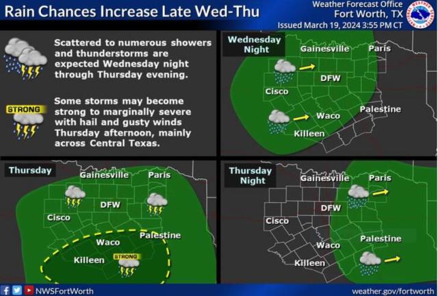
Strong to marginally severe storms are possible in Dallas-Fort Worth by Thursday afternoon with hail and “downburst thunderstorm winds” that will mostly hit areas along and south of I-20, according to the National Weather Service Fort Worth office forecast.
Heavy rainfall will accompany the storms with up to 2 inches expected east of the I-35, and the NWS warns of some flooding. To the west of I-35, up to an inch of rain is expected.
“Increasing clouds with showers and a few thunderstorms increasing late [Thursday] night, along with a strong storm or two with small hail and gusty winds over eastern Central Texas,” writes Fort Worth meteorologist Eric Martello on the NWS website. “Scattered showers and thunderstorms will persist primarily along/east of I-35 through Thursday evening and into Thursday night. Precipitation will exit into East Texas by early Friday morning.”

The storms are the result of a cyclone or low-pressure system intensifying as southerly winds gain strength. The severity of the storms will depend on localized instability, according to the NWS. The weather service earlier in the week pointed to possible hail and lightning for the area. Much of that forecast still holds, although the coming storms will not be as severe as the system that only days ago pummeled the Metroplex with baseball-size hail and at least one tornad.
The biggest change in the weather forecast is the relatively warmer temperatures across the Metroplex Thursday and into Friday. Expect highs in the 60s and low 70s heading into the weekend.
“The expansive cloud cover and increasing rainfall will minimize any radiational cooling . Combined with winds remaining up near 10 mph, lows will be 10 degrees or more above seasonal normals,” Martello writes.
By Sunday, we will see another set of storms arrive pushed along by high atmospheric instability from the deserts in the Southwest and emptying out to our region.
“With strong deep-layer shear present, severe weather potential will largely depend upon the degree of moisture return and destabilization that occurs out in the warm sector,” according to the NWS.


