
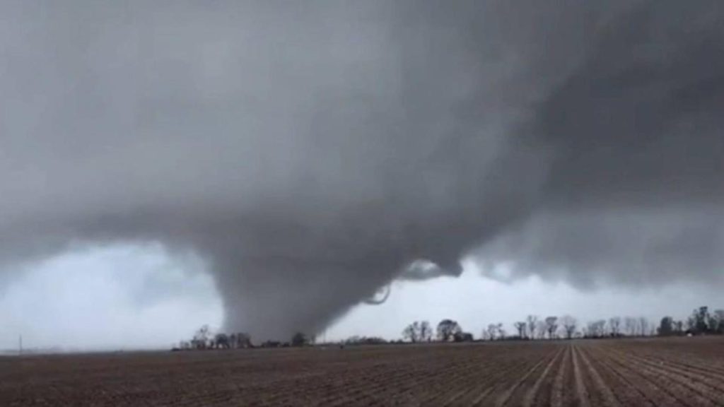
The weather over Middle Tennessee is looking more ominous by the hour. What started as a typical spring storm has turned into something far more dangerous. The National Weather Service has just extended the Tornado Watch through Thursday morning as severe thunderstorms continue to pound the region. These storms are capable of spawning tornadoes, unleashing damaging winds, and producing hail — all things Tennessee residents need to be prepared for.
What’s Going On Right Now:
If you’ve been feeling the tension in the air this morning, you’re not imagining it. The Tornado Watch is in effect for several counties, including Davidson, Rutherford, Williamson, and Wilson, and will remain until Thursday morning. This means conditions are favorable for tornadoes to form at any time. Forecasters are particularly concerned about Nashville, Murfreesboro, and Clarksville, which are already experiencing heavy rain, high winds, and dangerous lightning.
But here’s the real concern: This isn’t just a passing storm. The winds could gust up to 70 mph, and there’s a significant risk of tornadoes popping up unexpectedly. We could also see hail that’s large enough to cause damage to cars, homes, and crops. That’s not a storm you want to take lightly.
What’s Coming Next:
As the system moves across the state, conditions will only worsen. If you’re in the path of these storms, expect more rain (possibly flooding), and strong winds that could knock down trees and power lines. Areas like Nashville and surrounding counties are expected to feel the full force of these storms in the coming hours.
Even though the Tornado Watch doesn’t mean a tornado is guaranteed, it’s a signal that you need to be ready. Conditions are perfect for dangerous weather to develop quickly, so this is the time to prepare yourself.
What You Can Do to Stay Safe:
While the weather outside may seem calm, things can change in an instant. Here’s what you can do right now to protect yourself and your loved ones:
-
Stay Inside: If you’re not already at home, head there now and stay there. Do not attempt to travel while the weather is bad.
-
Prepare for Power Outages: With winds this strong, power outages are a real possibility. Keep your phone charged and have extra batteries, flashlights, and anything else you might need in case the lights go out.
-
Know What to Do If a Tornado Hits: If a tornado warning goes off, immediately head to a safe space — preferably in the center of your home or basement, away from windows. If you live in a mobile home or other temporary structure, don’t wait — find sturdier shelter.
-
Have an Emergency Kit: It’s always a good idea to be ready. Pack up some essentials like water, non-perishable food, medications, and a first-aid kit, just in case you get stuck without power or need to shelter in place for an extended period.
Why This Is Serious:
Tornadoes can form quickly, often with little warning. The combination of high winds, unstable air, and plenty of moisture makes this storm system particularly dangerous. Even if the skies look clear for a while, don’t let your guard down. You might not see the worst of it coming, but it could be headed your way fast.
It’s also important to remember that spring storms like this are notoriously unpredictable. While the worst of the weather may be happening now, things can escalate quickly, especially as nighttime approaches. Make sure you have weather alerts set on your phone and a weather radio nearby.
What You Should Do Now:
-
Stay Alert: Monitor the weather closely throughout the day. Conditions can change rapidly, and the sooner you know about a warning or new threat, the better.
-
Prepare for the Worst: Don’t wait for the tornado to show up to take action. If you’re in a Tornado Watch area, start thinking about where you’ll go if a warning comes. Better to be ready than caught off guard.
-
Don’t Panic, But Stay Ready: The key right now is being prepared. Keep calm, but know exactly what you’ll do if the situation changes. Having a plan makes all the difference in staying safe.

