
Northern California, it’s time to buckle up: a powerful spring storm is making its way toward us, bringing heavy rain and strong winds that could make for some pretty wild weather today and tonight. We’re looking at wind gusts up to 55 mph and the potential for flooding, which means it’s a good idea to be prepared. If you’re planning to be out and about, especially if you need to travel, you’ll want to stay on top of the forecast and take precautions. Here’s what you can expect.
What’s Coming: Wind and Rain That Could Pack a Punch
This storm will start to make its presence felt late this afternoon. By around 4 PM, you’ll notice the rain starting to pick up, and it will continue to intensify as we move through the evening. From 6 PM to midnight, expect the heaviest rain and the strongest winds. The rain will come down hard, possibly at rates of 1 to 2 inches per hour, so it won’t take long for roads to get slippery. Visibility will drop as well, so driving conditions will be tricky, to say the least.
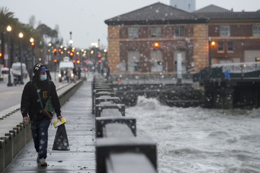
But it’s not just the rain you should worry about. Winds will be intense, with gusts reaching up to 55 mph in some coastal areas, and around 40-50 mph further inland. These winds could bring down trees and power lines, and flying debris could make being outside dangerous. If you don’t need to be out, it’s best to stay inside and off the roads, especially as the storm peaks later in the evening.
Travel Troubles Ahead: Be Ready for Dangerous Conditions on the Roads
If you have travel plans today or tonight, you might want to reconsider them, or at least be extra cautious. I-5, Highway 101, and other major roads will become slick as the rain picks up, and with the gusty winds, it’s going to be harder to control your car, especially if you’re driving a larger vehicle. Visibility could be poor, and you’ll also need to watch out for standing water that could cause you to hydroplane.
This storm isn’t just going to affect the Bay Area—it’s moving inland, too. Sacramento, Chico, and Redding are in for a wet, windy night, so if you can avoid travel between 5 PM and midnight, it might be best to wait until the storm has passed. If you’re on the road during the worst of it, remember to slow down and leave plenty of room between you and other cars.
Flooding Risk: Watch for Rising Waters in Vulnerable Areas
One of the biggest threats with this storm is flooding. Some areas are already saturated, and the heavy rain could overwhelm rivers and streams, leading to flash floods. Sonoma, Mendocino, and Lake counties are especially vulnerable. If you live near a river or creek, keep an eye on water levels, and be prepared in case the situation worsens. Flood watches are in effect, and you’ll want to take steps to protect your property if you’re in a flood-prone area.
How to Prepare: Simple Steps to Stay Safe
Here’s what you can do to make sure you stay safe and avoid the worst of the storm:
-
Stay Inside: The wind gusts can reach up to 55 mph, and being outside in that is not only uncomfortable—it can be dangerous. Stay inside as much as possible, especially when the winds are at their peak, and be cautious of flying debris.
-
Drive Cautiously: If you absolutely must be on the road, make sure to drive slowly and keep a safe distance from other vehicles. Watch for standing water, which can make roads more slippery, and avoid driving through flooded areas if you can. If you’re on bridges or highways, keep your hands on the wheel—strong crosswinds could make it tricky to maintain control.
-
Power Outages: It’s likely that high winds will cause some power outages, especially in rural areas. Have a flashlight, batteries, and a portable charger on hand, just in case. Make sure you have some snacks and water stocked up in case the power goes out for a while. And if you can, secure any outdoor items that could be blown around by the wind.
-
Monitor Flooding: If you live near any waterways, it’s a good idea to keep checking local weather reports and flood watches. If you’re in a flood zone, move any valuables or electronics to higher ground to prevent damage, and make sure you’re ready to evacuate quickly if necessary.
-
Secure Your Outdoors: Wind gusts of up to 55 mph are strong enough to send outdoor furniture, garbage cans, and plants flying. Bring anything loose inside to keep it from getting tossed around and causing damage.
What’s Next? Calm After the Storm
Once the storm passes, the skies will clear up and the winds will die down, giving us a calmer Friday. The rain will stop, and temperatures will be cooler, but at least the worst of the weather will be behind us. So while today and tonight will be wild, there’s light at the end of the tunnel.
Stay Safe, Northern California!
This storm is not one to take lightly. High winds, heavy rain, and the potential for flooding make this a serious weather event. The good news is that if you stay informed, prepared, and cautious, you’ll be able to ride out the worst of it safely.

