
Hey there, Ohio and Pennsylvania! We need to talk—tonight’s weather isn’t something to take lightly. A strong storm system is barreling toward us late Sunday night into early Monday morning, bringing damaging winds, large hail, and the real possibility of isolated tornadoes. And because these storms will hit while most of us are asleep, they’re even more dangerous. So let’s break it down and get you prepared.
When You Need to Be Ready
- Sunday Evening: You might notice a few scattered showers or rumbles of thunder, but the real trouble comes later. If you hear thunder before bed, take it as an early warning.
- Late Sunday Night (After 11 PM) – Early Monday Morning: This is when the storm really ramps up. A powerful line of storms will move through Ohio first, then into Pennsylvania while most people are sleeping. That’s why it’s critical to set up alerts that will wake you if warnings are issued.
- Monday Morning: The worst of the storm should be moving out around sunrise, but leftover rain, gusty winds, and possible power outages could make your morning commute messy.
Who’s in the Danger Zone?
- Eastern Ohio & Western Pennsylvania – These areas are in a Slight Risk (Level 2 out of 5), meaning severe storms are more likely here.
- Pittsburgh, Butler, Morgantown – A Marginal Risk (Level 1 out of 5) is in place, meaning storms could still turn severe, but they’ll be more scattered.
What This Storm Brings
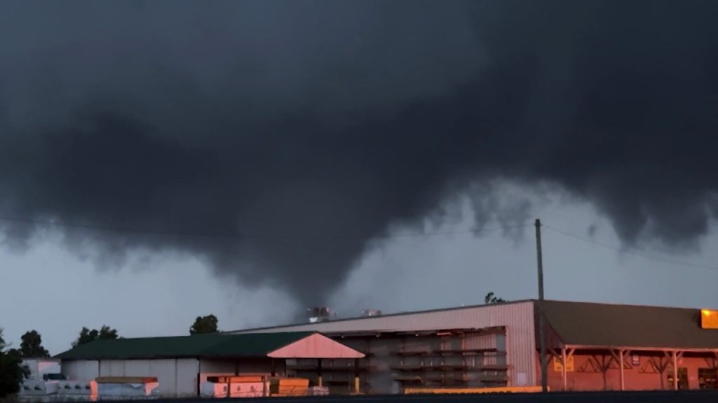
Tornadoes: They’re not expected to be widespread, but even a single tornado can cause serious destruction. Nighttime tornadoes are even riskier because they’re harder to see, and many people won’t hear warnings in time. Don’t take chances—act fast if a warning is issued!
Damaging Winds: Gusts up to 70 mph could knock down trees and power lines, leading to outages. Charge your phone now, and keep flashlights handy!
Large Hail: Some storms could drop hail the size of quarters or golf balls, which can damage cars, windows, and roofs. If you have a garage or carport, use it before heading to bed.
Here’s What You Should Do Right Now
✔ Find Your Safe Spot – If a tornado warning is issued, don’t hesitate—go to a small, windowless room on the lowest floor of your home.
✔ Stay Informed – Make sure your phone is charged and set to receive emergency alerts. If you sleep through everything, set an alarm to check the weather before bed.
✔ Stock Up on Essentials – Flashlights, extra batteries, first-aid supplies, non-perishable food, bottled water, and a phone charger could be lifesavers if the power goes out.
✔ Secure Outdoor Items – Strong winds can turn patio furniture, trash cans, and even loose decorations into dangerous projectiles. Bring them inside or tie them down!
What Happens After the Storm?
Once this storm clears out, temperatures will climb into the mid-70s and low 80s for the rest of the week. Another round of rain is possible by midweek, but it won’t be anywhere near as intense as this system.
Take This Seriously!
Overnight storms can be especially dangerous because they catch people off guard. Don’t assume you’re in the clear—stay alert and be ready. Check in with family, friends, and neighbors to make sure they’re prepared too.

