
Mother Nature is about to throw everything she has at us! A powerful storm system is set to strike Middle Tennessee, bringing dangerous thunderstorms, possible tornadoes, damaging winds, and even flash flooding before temperatures plunge into winter-like conditions.
This dramatic weather shift will be fast and intense, meaning residents need to stay alert and prepared for dangerous conditions. Storms are expected to ramp up Tuesday night, bringing powerful winds and heavy rain, followed by a brutal cold front that will send temperatures plummeting more than 30 degrees by Wednesday evening.
If you thought spring was here to stay, think again—this week’s weather will be anything but normal. Here’s what to expect and how to stay safe.
Storm Timeline: When Will the Worst Weather Arrive?
The first signs of trouble will arrive on Tuesday, March 5, when warm, humid air builds ahead of a powerful cold front. But the real danger begins Tuesday night, when conditions become ripe for severe thunderstorms and tornadoes.
- Tuesday Afternoon: Increasing clouds, gusty winds, and rising humidity. Highs will climb to 68°F (20°C).
- Tuesday Night: Severe thunderstorms expected after 7 PM, with damaging winds, hail, and possible tornadoes. Heavy rain could lead to flash flooding in low-lying areas.
- Wednesday Morning: The storm system moves out, but gusty winds continue as temperatures begin to drop rapidly. Morning lows near 52°F (11°C).
- Wednesday Afternoon: A drastic cooldown begins, with temperatures plummeting into the 30s by evening.
- Wednesday Night: A bone-chilling low of 35°F (2°C)—nearly 30 degrees colder than just 24 hours earlier! Wind chills could make it feel even colder.
This wild weather ride will leave many Nashvillians digging out their winter coats just one day after wearing t-shirts and shorts!
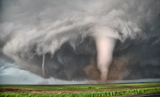
Tornado and Severe Thunderstorm Risks
Tuesday night’s storms could be extremely dangerous. The warm, humid air colliding with the incoming cold front creates the perfect recipe for severe thunderstorms and even tornadoes. The biggest threats include:
- Tornadoes: Some storms could quickly spin up tornadoes, meaning residents need to be prepared to seek shelter immediately if a warning is issued.
- Damaging Winds: Gusts up to 60-70 mph could down trees, power lines, and cause structural damage.
- Hail: Some storms may produce large hail capable of damaging cars and rooftops.
- Flash Flooding: Heavy rainfall in a short time could overwhelm drainage systems, leading to dangerous flooding on roads and in low-lying areas.
Nashville is no stranger to severe weather, but nighttime storms are especially dangerous because they can catch people off guard. Make sure you have a way to receive alerts, even while you’re sleeping

How to Stay Safe During the Storm
- Know Where to Go: If a tornado warning is issued, head to the lowest level of your home, away from windows, in a small interior room like a closet or bathroom.
- Have Multiple Weather Alerts: Keep a weather radio, emergency alerts on your phone, or a reliable weather app activated overnight.
- Prepare for Power Outages: Charge your phones, flashlights, and portable chargers ahead of time in case high winds take down power lines.
- Avoid Flooded Roads: If you see water covering a roadway, turn around, don’t drown! Just a few inches of water can sweep a car away.
- Prepare for the Temperature Drop: If you go out Wednesday morning, dress for warmth—temperatures will be much colder by the evening.
Why Is This Happening?
This wild weather shift is happening because of a powerful cold front clashing with warm Gulf air.
- Warm, humid air surging north from the Gulf of Mexico will fuel strong thunderstorms on Tuesday night.
- A powerful cold front sweeping in from the west will slam into this unstable air mass, creating violent weather.
- Once the storms push through, cold, dry air will rush in, sending temperatures plummeting in just a few hours.
Meteorologists say this is one of the strongest systems to hit Nashville in months, and its rapid changes could make for a dangerous situation if people aren’t prepared.
Final Thoughts
Nashville, this is not just another rainy night—this is a high-impact weather event. Severe thunderstorms, possible tornadoes, dangerous winds, and then a sudden drop into freezing temperatures all in less than 24 hours will make for a chaotic midweek weather shift.
- Be ready for storms.
- Prepare for the cold.
- Stay alert, and don’t take this system lightly!
This one-two weather punch could be a serious threat, so stay informed, be prepared, and take action to keep yourself and your family safe

