
San Diego is preparing for a major storm system that could bring heavy rainfall, dangerous flooding, and powerful winds across the region over the next few days. Forecasters warn that this storm has the potential to cause significant disruptions, including hazardous driving conditions, downed trees, and power outages.
Flooding Threat Looms as Heavy Rain Moves In
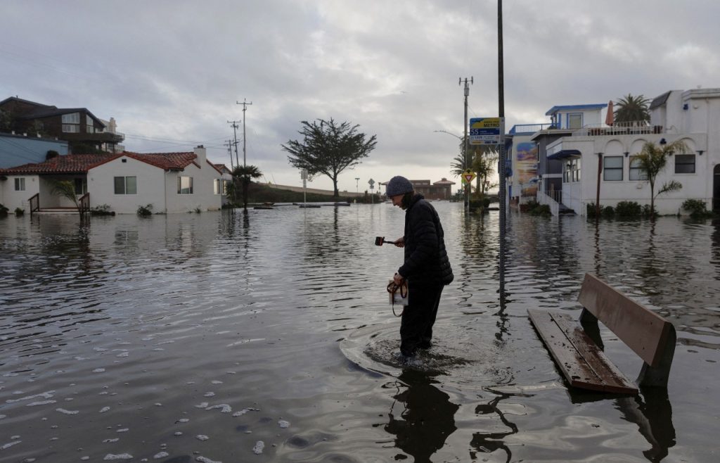
The National Weather Service has issued a Flood Watch for San Diego County from Thursday morning through early Friday. A powerful atmospheric river is set to drench the area, bringing rainfall rates as high as 0.75 inches per hour in some locations.
This kind of intense rain can quickly overwhelm storm drains, flood roads, and cause rivers and creeks to rise dangerously fast. Areas with poor drainage or a history of flooding—such as Mission Valley and parts of South Bay—should be on high alert.
Even before the heaviest rainfall arrives, there’s concern that saturated soil could lead to early flooding, making certain roads and underpasses impassable. Residents in low-lying areas should be prepared to evacuate if necessary and avoid driving through flooded streets. Remember: Just a few inches of fast-moving water can carry away a vehicle.
Howling Winds Could Knock Out Power and Bring Down Trees
Adding to the storm’s impact, a High Wind Warning has been issued for areas near the San Bernardino County Mountains from Thursday morning through early Saturday. Winds will be especially fierce on Thursday night into early Friday, when gusts could reach up to 75 mph in some elevated areas.
Even in lower elevations, wind speeds of 30 to 40 mph with gusts up to 50-65 mph could bring down trees, damage power lines, and create dangerous travel conditions.
Power outages are a major concern, especially in areas prone to falling trees. If you haven’t already, now is the time to charge your devices, check your emergency kits, and secure any outdoor furniture or decorations before the worst of the winds hit.
High-profile vehicles, such as trucks, vans, and RVs, should exercise extreme caution on highways, particularly along Interstate 8 and other wind-prone areas where strong gusts could make driving hazardous.
San Diego’s Coastline Also Faces Rough Conditions
The storm will also create dangerous ocean conditions along the coast. While a High Surf Advisory has not yet been issued, large waves, strong rip currents, and rough seas are expected.
Beachgoers and surfers should avoid venturing into the water during the storm. Even experienced swimmers can be caught off guard by sudden powerful waves and changing tides.
Additionally, low-lying coastal areas could see minor flooding, especially during high tide periods. If you live near the coast, keep an eye on forecasts for possible coastal flood advisories.
What You Should Do to Stay Safe
- Stay Informed – Monitor local news, weather updates, and emergency alerts to stay ahead of changing conditions.
- Prepare for Power Outages – Charge electronic devices, have flashlights ready, and stock up on extra batteries.
- Avoid Flooded Areas – Do not attempt to drive or walk through standing water—it’s deeper and more dangerous than it looks.
- Secure Outdoor Items – Bring in loose objects like patio furniture, trash cans, and garden decorations to prevent them from being blown away.
- Use Caution When Driving – Roads will be slick, and falling branches or debris could create hazards. If you must drive, take it slow and watch for road closures.
Final Thoughts: A Serious Storm That Shouldn’t Be Ignored
This storm isn’t just another rainy day in San Diego—it has the potential to bring serious flooding, damaging winds, and major disruptions.
Even though the worst of the storm will pass by Friday, its effects could linger into the weekend, especially in areas where flooding or power outages occur.
San Diego residents should take this storm seriously, stay prepared, and avoid unnecessary risks. If you live in a flood-prone area, be ready to act quickly—it’s always better to be overprepared than caught off guard.

