
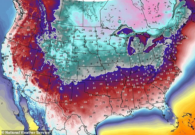
Get ready, Kentucky! An arctic blast is set to sweep across the state starting Sunday, bringing bitterly cold temperatures and sub-zero wind chills. With frostbite risks and icy conditions expected, residents are urged to prepare now for the extreme weather ahead.
The National Weather Service has issued warnings across the region as a polar vortex plunges temperatures well below freezing. Highs in major cities like Louisville, Lexington, and Bowling Green will struggle to reach 30°F (-1°C), while overnight lows will drop into the single digits.
What to Expect
- Frigid Temperatures:
- Louisville: Highs around 28°F (-2°C) Sunday, with lows as cold as 6°F (-14°C) by Tuesday night.
- Lexington: Daytime highs near 19°F (-7°C) Monday, with nighttime lows dipping to 4°F (-16°C).
- Bowling Green: Highs in the mid-20s, with lows around 10°F (-12°C).
- Dangerous Wind Chills: Brisk winds will make it feel 10-20 degrees colder, with frostbite possible on exposed skin within minutes.
How It Might Affect You
- Health Risks: Frostbite and hypothermia are significant concerns for those exposed to the cold for prolonged periods.
- Icy Roads: Light snow and freezing temperatures could create hazardous travel conditions, particularly at night.
How to Stay Safe
- Limit Outdoor Time: Stay indoors as much as possible to avoid exposure to dangerous wind chills.
- Bundle Up: If heading out, wear insulated layers, hats, gloves, and scarves to protect against the cold.
- Monitor Weather Updates: Stay informed through the National Weather Service and local alerts for updates.
- Winterize Your Home: Prevent pipes from freezing by leaving faucets dripping and keeping indoor spaces warm.
As Kentucky braces for this extreme cold snap, residents are encouraged to take precautions to stay safe and warm. With wind chills falling below zero and temperatures at dangerous lows, preparation is key to weathering this arctic blast. Stay safe, Kentucky

