
If you’re in or near the Absaroka and Beartooth Mountains or the Red Lodge Foothills, take note: a serious Winter Storm Warning is in effect, bringing heavy snow, gusty winds, and dangerous travel conditions through Friday morning. Whether you’re planning to travel or just going about your day, it’s important to know what’s coming your way so you can stay safe.
What You Need to Know:
-
Heavy Snowfall Coming Through the Night: Starting Thursday evening, snow will begin to fall, but by the time you wake up Friday morning, you might be dealing with up to 12 inches or more of snow, especially in the mountains. If you’re familiar with Montana winters, you know that when snow falls fast and heavy, it can make roads slippery quickly. The snow won’t just blanket the ground; it’s going to come down hard, reducing visibility and creating slick conditions.
-
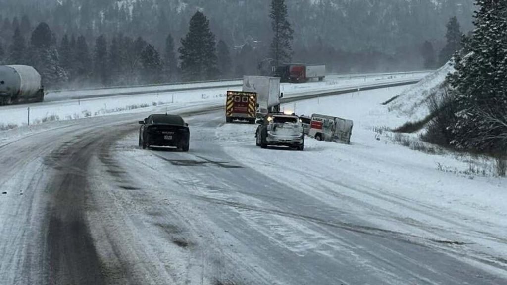
Travel is Going to Be Tough: If you have plans to hit the road, you might want to reconsider. Snow and ice will cover the roads, making driving extremely dangerous. Expect slick roads, snowdrifts, and poor visibility—even for experienced drivers. This storm will make mountain roads and foothill highways, like US-212, treacherous, and if you’re not careful, you might find yourself sliding around or getting stuck in the snow. If you have to drive, make sure your car is prepared, but it’s safer to stay put if possible.
-
Timing: The storm will really pick up Thursday evening, continuing through the night and into the early morning hours of Friday. Expect the worst conditions to hit between midnight and 9 AM Friday, with snow slowing down after the morning. That said, road conditions will still be bad well into Friday afternoon in the mountains and foothills.
Why This Matters:
This isn’t just a light snowstorm—it’s going to be serious. Here’s why you should take the warning seriously:
-
Heavy Snow = Dangerous Roads: Snow can pile up quickly, and even a few inches of snow can turn roads into icy, slippery messes. When combined with the strong winds expected in the higher elevations, visibility will be poor, and travel will be hazardous. Your usual route could become completely impassable in a matter of hours. If you’re heading out, be prepared for slow, difficult driving—it could take longer than you expect to get anywhere safely.
-
Snow Drifts and Blizzard-Like Conditions: Winds will gust up to 40 mph, and with the heavy snow, blowing snow will create white-out conditions that make seeing the road almost impossible. This is a recipe for dangerous, near-blizzard conditions—so even if you’re an experienced winter driver, the snow and wind will be enough to make the roads hard to navigate.
-
Travel Delays and Road Closures: Roads are likely to become blocked by snowdrifts or accidents, and it’s possible that some roads will be closed temporarily. Expect long delays, and if you’re planning to drive, keep in mind that you may have to reroute your trip. Even if the roads aren’t closed, they’ll still be dangerous and packed with snow and ice.
How to Stay Safe:
-
Avoid Travel If You Can: If you can avoid traveling during the storm, do it. The best advice is to stay off the roads unless you absolutely need to go somewhere. Even if you can’t delay a trip, try to travel during daylight hours when visibility is slightly better, but be aware that conditions can change fast.
-
Get Your Car Ready: If you have to go out, make sure your vehicle is winter-ready. Snow tires are a must, and it’s a good idea to pack emergency supplies: blankets, snacks, water, a flashlight, and a fully charged phone. Make sure your gas tank is full before you head out—you don’t want to get caught low on fuel if you get stuck somewhere. And, drive slowly and cautiously—give yourself plenty of time to stop if you need to.
-
Keep Up With Weather Updates: Things are changing fast. Monitor the weather throughout the evening and night so you’re aware of any changes. Local news apps, radio, or weather websites will have the latest information on road closures, accidents, or updated warnings. If you’re already out driving, and things get worse, consider turning around and heading home.
-
Expect Possible Power Outages: With heavy snow and wind, power lines could go down, especially in more rural areas and in the mountains. It’s a good idea to have backup supplies—flashlights, extra batteries, water, and some extra food—just in case the power goes out where you are. Keep your phone charged, too, in case you need it to stay in touch with loved ones or get emergency updates.
What to Expect:
-
Snow Accumulation: In the higher elevations, up to 12 inches or more of snow could fall before the storm subsides on Friday morning. Even in the Red Lodge Foothills, you’ll see significant snowfall, which will create icy, snowy roads and possible snowdrifts.
-
Wind Gusts: Winds will gust up to 40 mph, causing blowing snow and making driving visibility close to zero in some areas. If you’re heading out early Friday, expect these strong winds to make travel incredibly difficult.
-
Travel Disruptions: Expect major delays and possible closures on roads throughout the region. If you need to travel, plan for long trips with potential detours or roadblocks. And again, if you don’t need to be out there, stay home.

