
Houston, brace for impact! A powerful storm system is charging toward Southeast Texas, bringing a rare and dangerous combination of extreme weather—an enormous dust storm, possible tornadoes, and heavy flash flooding. What started as a routine weather disturbance has rapidly intensified, creating a potentially life-threatening situation for millions across the region.
Already, cities to the west of Houston have reported near-zero visibility due to dense dust clouds, and now that same threat is barreling toward the metro area. The National Weather Service (NWS) has issued urgent warnings, advising residents to stay indoors, avoid unnecessary travel, and prepare for extreme conditions as Houston faces its most unpredictable storm of the year.
Houston Braces for Severe Weather – What You Need to Know
Meteorologists are tracking an unusual and powerful storm system that is expected to slam into the Houston metro area today, Wednesday, March 5. This storm is bringing multiple extreme weather threats all at once, making it one of the most dangerous weather events the city has seen in recent months.
Here’s what’s coming:
- Unprecedented Dust Storms – A massive dust cloud, fueled by strong winds from a Pacific cold front, is racing toward Houston, reducing air quality and making it difficult to breathe, especially for those with respiratory conditions.
- Tornado Threat Increases – The same system has already spawned tornadoes in the Midwest, and conditions are now becoming favorable for twisters to form in Southeast Texas.
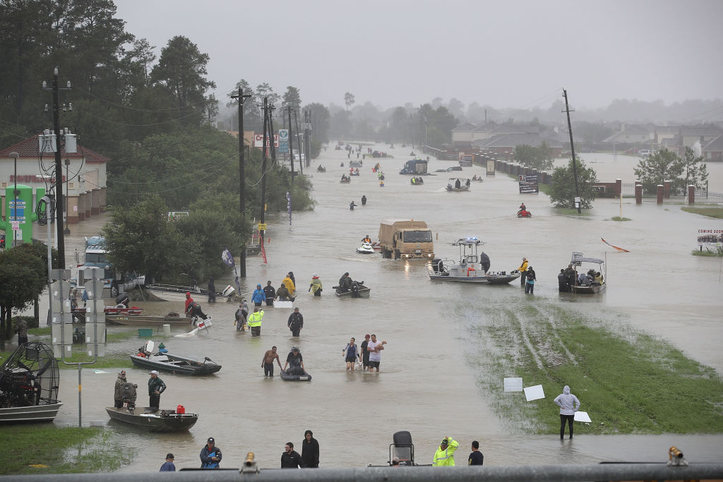
- Flash Flooding Expected – With up to 3 inches of rain expected in some areas, low-lying roads and underpasses could become completely impassable within hours.
- Damaging Winds Up to 60 MPH – Gusty winds could snap tree branches, damage homes, and knock out power for thousands of residents.
- Severe Thunderstorms & Lightning – Frequent cloud-to-ground lightning strikes could pose additional risks to anyone outdoors.
How Will This Storm Impact Houston?
- Air Quality Alert – Houston’s air is expected to be filled with thick dust particles, making it hazardous to breathe for those with asthma or other respiratory conditions. Officials recommend wearing masks or staying indoors.
- Traffic & Travel Disruptions – The dust storm is reducing visibility to dangerously low levels, and flooding from the heavy rain could make major highways too dangerous to drive on. Expect delays, detours, and potential road closures.
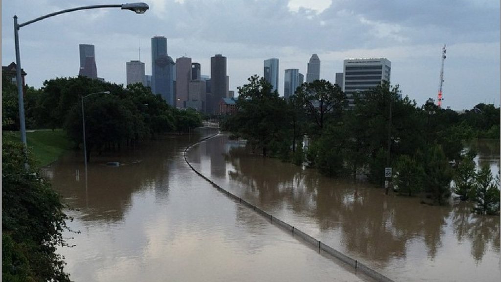
- Flooded Streets & Low-Lying Areas at Risk – The city’s flood-prone areas could experience rapid water buildup, turning underpasses and bayou-adjacent roads into dangerous zones.
- Power Outages Expected – Strong winds are capable of knocking down power lines, leaving thousands without electricity. Charge your phones and prepare for possible outages.
Why Is This Storm So Dangerous?
- RARE COMBINATION OF THREATS – It’s highly unusual to have dust storms, tornadoes, and flash floods all hitting at once. Houston is facing a one-two punch of extreme conditions.
- FLOODING RISK IS HIGH – Houston’s infrastructure struggles to handle heavy rainfall in short periods, meaning neighborhoods near bayous, creeks, and flood-prone roads could see water levels rise fast.
- DANGEROUS WINDS COULD CAUSE DAMAGE – Winds up to 60 mph are strong enough to knock down trees, damage homes, and send outdoor objects flying.
- TRAVEL WILL BE EXTREMELY DANGEROUS – Between poor air quality from dust storms, low visibility on the roads, and rising water levels, traveling in these conditions could be life-threatening.
How to Stay Safe During Houston’s Severe Weather Crisis
- Stay Indoors as Much as Possible – The combination of dust, wind, and rain makes outdoor activities dangerous. Avoid unnecessary travel.
- Avoid Flood-Prone Roads – If you see water covering a roadway, turn around, don’t drown! It only takes a few inches of water to sweep a car away.
- Secure Outdoor Items – Bring in patio furniture, trash bins, and lightweight decorations before they become airborne projectiles in high winds.
- Charge Your Devices – Power outages are likely. Charge your phone, keep flashlights handy, and have backup power sources if needed.
- Be Prepared for More Storms – This severe weather pattern is expected to last through the week, meaning additional storms could develop soon.
Final Thoughts: Houston’s Weather Disaster is Just Beginning!
Houston is no stranger to storms, but this one is throwing everything at the city at once. A massive dust storm, a serious tornado threat, and life-threatening flash floods all converging in a single day is something the region rarely experiences.
Residents should take this storm seriously and prepare for disruptions, power outages, and potentially dangerous conditions over the next 24-48 hours. Don’t underestimate this storm’s impact—stay alert, stay indoors, and be ready for anything!

