
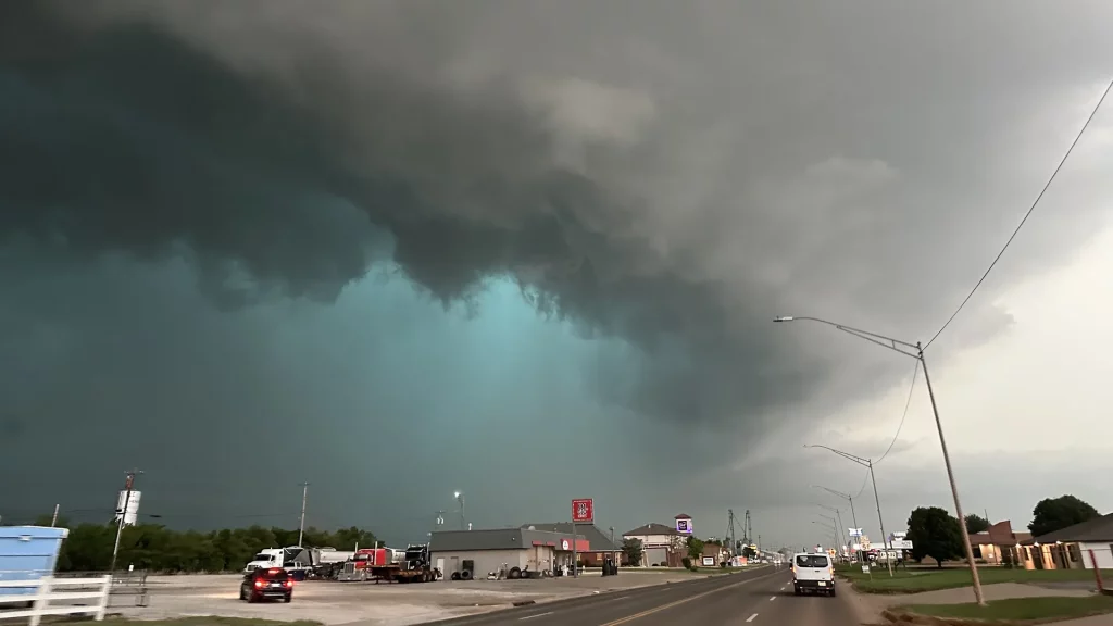
Nashville, get ready for a wild and dangerous weather shift! A massive storm system is heading straight for Middle Tennessee, bringing tornadoes, severe thunderstorms, damaging winds, and flash flooding. If you thought spring was going to start off calm, think again—this system has the potential to cause widespread damage, knock out power for thousands, and turn streets into rivers.
Forecasters are warning that strong winds over 60 mph, torrential rain, and rapidly forming tornadoes could hit as early as Wednesday afternoon, lasting through the night. The National Weather Service is closely monitoring the situation and has urged residents to prepare now, stay off the roads during peak storm hours, and have an emergency plan in place.
Nashville Braces for Severe Weather – Here’s What’s Coming
Meteorologists are tracking a powerful line of storms that is expected to arrive in Middle Tennessee on Wednesday afternoon and intensify throughout the evening. The primary threats from this system include:
- Tornadoes: Conditions are favorable for the formation of tornadoes, which could develop quickly and without much warning.
- Damaging Winds: Gusts could exceed 60 mph, knocking down trees, ripping off roofs, and causing power outages across the region.
- Flash Flooding: The storm will bring 1 to 3 inches of rain, and with recent rainfall saturating the ground, flooding is almost guaranteed in some areas.
- Intense Thunderstorms: Expect frequent lightning, booming thunder, and even hailstones in parts of Middle Tennessee.
- Treacherous Road Conditions: Roads will quickly flood, especially in low-lying areas and near creeks, making travel extremely dangerous.
Authorities are urging residents to stay indoors, charge their devices, and take precautions before conditions deteriorate.
How Much Rain and Wind Will Nashville Get?
- Rainfall Totals:
- Most areas will see 1 to 3 inches of rain, with some locations possibly exceeding 4 inches in stronger storms.
- Wind Gusts:
Winds will reach speeds of 50-65 mph, which is strong enough to bring down trees and power lines, leading to widespread outages. - Temperature Drop:
The storm will bring a quick drop in temperatures, falling from 61°F during the day to a chilly 46°F at night.
Why This Storm Is More Dangerous Than a Typical Thunderstorm
- TORNADO OUTBREAK POSSIBLE – The storm system has strong wind shear, meaning tornadoes could form rapidly.
- HURRICANE-FORCE WIND GUSTS – Wind speeds reaching 65 mph could rip apart roofs, send debris flying, and knock down power lines.
- FLOODING THREAT INCREASED – Because the ground is already wet from previous rains, this storm could cause significant flash flooding.
- EXTREMELY DANGEROUS DRIVING CONDITIONS – Heavy rain, flooded roads, and downed trees could make travel nearly impossible.
How to Stay Safe During Nashville’s Severe Weather Event
- Prepare for Power Outages – With high winds expected, charge your phone, have flashlights ready, and stock up on batteries.
- Secure Outdoor Items – Bring in patio furniture, grills, trash cans, and anything else that could turn into a flying hazard.
- Stay Off the Roads if Possible – Avoid driving during peak storm hours, especially in areas prone to flooding.
- Have a Tornado Plan – If a tornado warning is issued, go to an interior room or basement immediately.
- Check for Weather Alerts – Stay updated on warnings and watches because this storm could change rapidly.
Final Thoughts: Nashville’s Weather Nightmare Is About to Begin!
This storm is not just another rainy day—it’s a severe weather event that could bring tornadoes, dangerous winds, and life-threatening flooding. Forecasters are urging everyone in Middle Tennessee to take this storm seriously, prepare for power outages, and avoid unnecessary travel.
If you haven’t made an emergency plan, now is the time. Don’t wait until the storms are already here—by then, it may be too late! Stay informed, indoors, and safe as Nashville prepares for a violent weather outbreak.

