
If you live in Kentucky, Missouri, or Indiana, keep an eye on the sky this weekend—a powerful storm system is moving in, bringing the risk of heavy rain, flooding, and even the chance for severe storms, including a few tornadoes.
While the tornado threat is higher in the Deep South, that doesn’t mean our region is in the clear. Strong storms, damaging winds, and flash flooding could make for a dangerous weekend, especially Saturday night into early Sunday morning. If you have plans, it’s time to stay weather-aware and prepare for changing conditions.
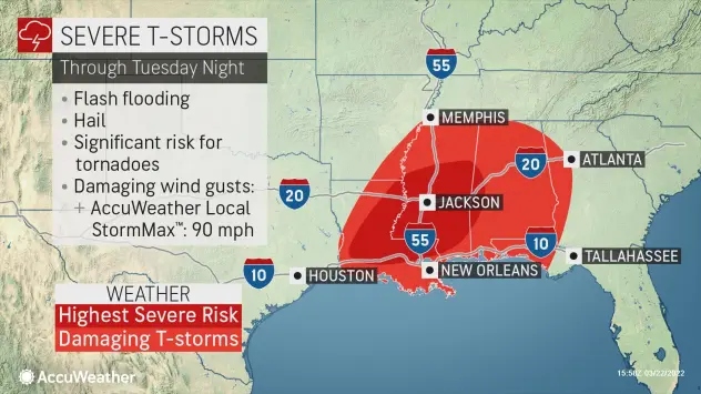
Flash Flooding Risk: Roads Could Become Rivers
When?
- Rain will start Saturday morning (Feb. 15) and continue through Sunday morning (Feb. 16).
- The heaviest downpours are expected Saturday evening into early Sunday.
How Much Rain?
- Some areas could see 2 to 4 inches of rain, possibly more in spots.
- Urban areas and low-lying regions are most at risk for sudden flash flooding.
Flood Watch Issued
- The National Weather Service has issued a Flood Watch for parts of Kentucky, Missouri, Indiana, and southern Illinois from midnight Saturday through early Sunday morning.
What This Means:
- Flooded roads can appear suddenly—never drive through standing water!
- If you live near a river, creek, or flood-prone area, be ready for rising water.
- Turn around, don’t drown! Just 6 inches of moving water can knock you down, and a foot of water can carry away a car.
Tornado & Severe Storm Risk: Stay Alert!
Who’s at Risk?
- The highest tornado threat is in the Deep South, but isolated severe storms could still impact Kentucky, Missouri, and Indiana.
- Strong storms could bring damaging winds, heavy rain, and even an isolated tornado late Saturday night.
When?
- The worst weather is expected Saturday evening into early Sunday morning.
- Nighttime storms are especially dangerous because people are asleep and may not get warnings.
What This Means:
- Even if the tornado risk is low, storms could still be dangerous.
- Have a weather radio or phone alerts turned on overnight in case of warnings.
- Strong winds and heavy rain can knock out power, so charge your devices in advance.
How to Stay Safe This Weekend
Flood Safety
- Never drive through flooded roads—it only takes a few inches of water to wash your car away.
- Be prepared to move to higher ground if you live in a flood-prone area.
- Check local road conditions before heading out.
Severe Storm & Tornado Safety
- Make sure you have a way to receive weather alerts, like a phone app or weather radio.
- Know your safe place—a basement or interior room away from windows is best.
- Have flashlights, extra batteries, and a phone charger ready in case of power outages.
Travel Precautions
- If possible, avoid traveling late Saturday night when conditions could be at their worst.
- If you’re caught in heavy rain while driving, slow down and pull over if needed.
Heavy rain could lead to flash flooding—don’t take chances on flooded roads.
Severe storms could bring strong winds, heavy rain, and even a tornado—stay prepared.
If you have travel plans, check the forecast often—conditions can change quickly.

