
Seattle is stepping into a chilly, wet week, with rain, snow, and freezing temperatures creating tricky conditions for anyone on the road. If you’re planning to head out, you’ll want to keep an eye on the forecast and prepare for slippery streets, potential black ice, and even some power outages. This isn’t your typical drizzle—it’s the kind of wintry mix that could turn your morning commute into a challenge.
Here’s what’s coming and how to stay safe.
Today’s Forecast (Thursday, February 6): Chilly, Wet, and Slippery
The day kicks off with a mix of clouds, sun, and occasional rain or snow showers. The high will be 42°F (6°C), but it won’t feel that warm thanks to the cold air. By evening, temperatures will drop to 28°F (-2°C), and that’s when things could get tricky.
Any moisture left on the roads or sidewalks is likely to freeze overnight, creating slippery patches and black ice. Drivers and pedestrians should take extra caution, especially on bridges and overpasses, which freeze faster than regular roads.
What to Expect for the Rest of the Week
- Friday, February 7: The sun may peek through the clouds, but it’ll still be chilly. Highs will reach 40°F (4°C), and lows will dip to 30°F (-1°C).
- Saturday, February 8: A mix of clouds and sunshine with a high of 42°F (6°C). Overnight, temperatures will fall to 31°F (0°C), so expect icy patches in the morning.
- Sunday, February 9: More clouds and sun, but the cold temperatures will stick around. Highs will be 43°F (6°C), with lows near 28°F (-2°C).
- Monday, February 10: A mix of rain and snow returns, with daytime highs of 42°F (6°C). Temperatures will drop sharply overnight to 22°F (-6°C), increasing the risk of icy conditions.
- Tuesday, February 11: Mostly cloudy and cold. A morning flurry could turn into light rain by the afternoon. The high will be 36°F (2°C), with a low of 20°F (-6°C).
Why This Week Could Be Risky
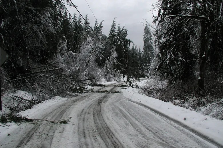
Seattle knows how to handle rain, but when you throw in freezing temperatures and snow, it’s a different story. Black ice is the main concern this week. Unlike regular ice, black ice is nearly invisible and forms when wet roads freeze overnight. It can be especially dangerous for drivers who may not realize they’re on a slick patch until it’s too late.
Bridges, overpasses, and shaded areas are the most likely places for black ice to form. Even if roads look clear, they could still be hazardous.
The weight of wet snow and freezing rain could also cause tree branches to snap, potentially knocking out power in some areas. If you’ve experienced outages in the past during winter storms, it’s a good idea to charge your devices and have emergency supplies on hand.
Timing Is Everything
The worst travel conditions are expected during the Wednesday evening and Thursday morning commutes. As snow and freezing rain coat the city, roads will be slick and visibility could be reduced. Even after the snow stops, freezing temperatures overnight will cause refreezing, making Friday morning just as risky.
If you don’t need to travel during these peak times, consider staying home or delaying your commute until conditions improve.
How to Stay Safe This Week
- Take It Slow on the Roads: Reduce your speed and give yourself extra time to brake, especially on bridges and overpasses.
- Avoid Sudden Movements: If you hit a patch of ice, don’t slam on the brakes or jerk the steering wheel. Ease off the gas and steer gently.
- Watch Where You Step: Sidewalks, stairs, and driveways could be slick, so wear boots with good traction and walk carefully.
- Prepare for Power Outages: Charge your phones and have flashlights, batteries, blankets, and food ready in case you lose power.
- Layer Up: The cold can creep in quickly, so dress warmly in layers, and don’t forget a hat and gloves if you’ll be outside for long periods.
When Will It Get Better?
The cold and wet conditions aren’t going anywhere soon. While daytime sun might melt some of the ice, overnight refreezing is expected to keep things slippery, especially in the mornings. Monday’s mix of rain and snow will likely add to the mess, so it’s important to stay flexible with your plans and check the forecast regularly.
The Bottom Line
This week’s weather is a reminder of how quickly things can turn messy in Seattle. While the city is no stranger to rain, the added threat of snow, freezing temperatures, and black ice means extra caution is needed. Take your time, stay warm, and be prepared for delays if you’re traveling.
If you can, enjoy the cozy side of winter—there’s nothing wrong with staying indoors with a hot drink while the city battles the elements. Just remember that spring isn’t too far away.

