
Maine, it’s not over yet—winter’s making one last appearance. Just when you thought spring might finally be settling in, a winter storm is sweeping across the state, and it’s set to dump 4 to 6 inches of snow by tonight. While this isn’t a huge storm, it’s still enough to create some slippery roads and poor visibility, especially for those heading out this evening. Don’t worry, though—the snow will begin to taper off by late Monday, and we’ll be back to quieter weather soon. Here’s what you need to know.
What’s Happening:
-
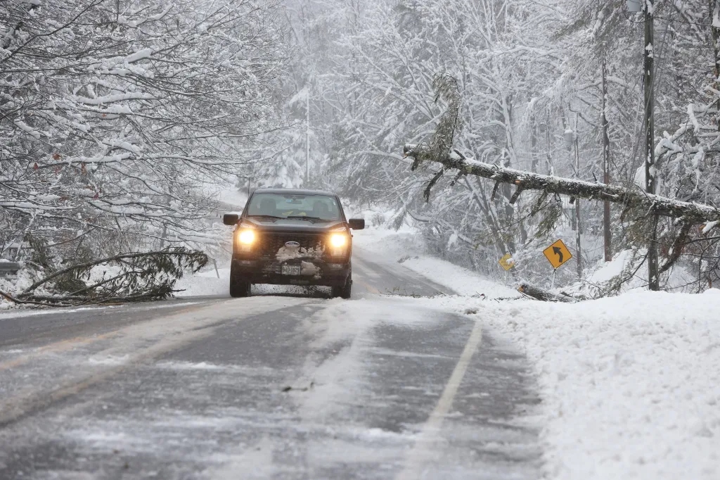
Winter Storm in Progress: A winter storm is moving through Maine, bringing moderate to heavy snow throughout the day and into the night. While it’s not a major snowstorm, it will still leave behind 4 to 6 inches of snow across much of the state, making roads slick and travel difficult. You’ll want to keep an eye on the roads if you’re heading out, particularly tonight when the heaviest snow is expected. The storm will ease up by Monday night, but travel will still be tricky for a while.
-
Timing of the Snow: Snow will start to pick up this afternoon and continue through the evening, with the heaviest snow expected to fall tonight. The snow will gradually lighten up by Monday night, and by Tuesday morning, the storm will be largely over. But be aware that the snow will leave behind icy conditions, so the roads won’t be fully clear until Tuesday.
-
Travel Hazards: If you plan on traveling, expect slippery roads and poor visibility—especially after dark. The secondary roads and rural areas will be most affected, so be cautious if you’re heading out in those directions. The main highways should be better maintained, but they could still be slick in spots. Also, be prepared for black ice, which is always a concern when temperatures dip below freezing and snow starts to melt.
What to Expect:
-
Monday (March 24): Snow will begin falling today, with the heaviest snow expected in the evening. If you’re heading out tonight, be ready for slippery spots and reduced visibility, especially in the more remote areas. Temperatures will stay in the low 30s, which means the snow will stick, and it will be harder for roads to clear overnight. If possible, avoid travel after dark, as conditions will deteriorate quickly.
-
Tuesday (March 25): By Monday night, the snow should start to taper off, but don’t expect everything to be smooth sailing by morning. Icy patches will still be around, and mountain areas could remain snow-covered. The storm will wrap up by Tuesday, but we’ll still need to be cautious of icy roads and hidden patches of snow.
How to Stay Safe:
-
Slow Down and Be Careful: As always with snow, slow down if you need to be on the roads. Visibility will be low, especially during the heaviest snow, and the roads will be slick. Keep plenty of distance from other vehicles and avoid sudden movements. If you don’t have to be out, stay home and stay safe. It’s just not worth risking a drive during a storm.
-
Watch for Ice: Even once the snow stops, you’ll need to be extra careful for icy spots. Bridges and overpasses freeze first, and untreated roads could be just as slick as they were when the snow was falling. Black ice is sneaky, so if you’re walking outside, watch your step, especially in the early morning hours.
-
Stay Informed: Weather conditions can change fast, so make sure to check in with your local forecast and keep an eye on traffic updates. Roads may be slick even after the snow ends, so it’s a good idea to stay updated with the latest information before you head out.
Why This Is Happening:
It’s that time of year in Maine where winter just can’t quite let go. Even though it’s officially spring, we’re still seeing cold air from the north sweeping down, keeping temperatures low enough to allow for snow. With conditions like this, it’s not uncommon for Maine to experience a late-winter storm—especially in the mountains and inland areas, where snow tends to accumulate more. We’re almost there, but winter still has a little bit of bite left!
Quick Recap:
-
What to Expect: A winter storm bringing 4 to 6 inches of snow tonight, with heavier snow expected during the evening hours. Roads will be slick, and visibility could be poor. Snow will taper off by Monday night, but icy conditions will linger through Tuesday morning.
-
When: Snow will continue through tonight, easing up by Monday night. Tuesday will be calmer, but icy patches could still be around, especially in the mountains.
-
What You Can Do: If you don’t need to travel tonight, stay home. If you must go out, drive cautiously, slow down, and keep an eye on road conditions. Be mindful of icy spots, especially on secondary roads and untreated surfaces.
This late winter storm is a reminder that, in Maine, you can never quite say goodbye to snow until it’s truly gone. Stay safe out there, and keep an eye on the weather as we ride out this final winter blast before spring officially takes hold.

