BranFord News

Weather Forecast Team

Heads Up, Arkansas! Light Snowfall Could Make Roads Slippery in the Ozark Region

Heads Up, Arkansas! Light Snowfall Could Make Roads Slippery in the Ozark Region

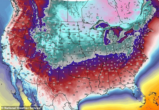
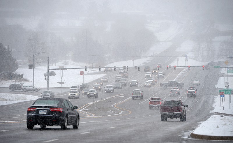
Get ready, Arkansas! Light snow is expected to sweep through the Ozark and Ouachita Mountains today, potentially making roads slippery and visibility tricky. With snow totals reaching up to an inch in higher elevations, travelers are advised to stay cautious. Here’s what you need to know The National Weather Service has issued a winter weather […]

Heads Up, Arkansas! Light Snowfall Could Make Roads Slippery in the Ozark Region Read More »

Brace for the Deep Freeze: Dangerous Cold Watch for Alabama, Florida, and Mississippi

Brace for the Deep Freeze: Dangerous Cold Watch for Alabama, Florida, and Mississippi

Heads up, South! An Arctic blast is bringing dangerously cold temperatures to Alabama, Florida, and Mississippi starting Sunday. With sub-freezing temperatures and possible icy conditions, residents are urged to take precautions to protect themselves from frostbite, hypothermia, and hazardous travel. Here’s what you need to know. The National Weather Service has issued an Extreme Cold

Brace for the Deep Freeze: Dangerous Cold Watch for Alabama, Florida, and Mississippi Read More »

Winter Chaos: Severe Cold and Snow Set to Paralyze Illinois and Indiana

Winter Chaos: Severe Cold and Snow Set to Paralyze Illinois and Indiana

Brace yourselves, Midwest! Illinois and Indiana are set to experience a dangerous combination of bitterly cold temperatures and significant snowfall starting Sunday. With sub-zero wind chills, icy roads, and frostbite risks, residents are urged to prepare now for the Arctic blast. The National Weather Service has issued warnings for extreme cold and snow as a

Winter Chaos: Severe Cold and Snow Set to Paralyze Illinois and Indiana Read More »

Polar Vortex Warning: Sub-Zero Wind Chills and Arctic Freeze to Slam Kentucky

Polar Vortex Warning: Sub-Zero Wind Chills and Arctic Freeze to Slam Kentucky

Get ready, Kentucky! An arctic blast is set to sweep across the state starting Sunday, bringing bitterly cold temperatures and sub-zero wind chills. With frostbite risks and icy conditions expected, residents are urged to prepare now for the extreme weather ahead. The National Weather Service has issued warnings across the region as a polar vortex

Polar Vortex Warning: Sub-Zero Wind Chills and Arctic Freeze to Slam Kentucky Read More »

Sunny with a Breeze! Miami-Dade’s Sunday Shaping Up to Be Beautiful

Sunny with a Breeze! Miami-Dade’s Sunday Shaping Up to Be Beautiful

Good news, Miami! Sunday’s forecast brings breezy conditions, partly sunny skies, and minimal rain chances, making it a perfect day to enjoy outdoor activities. With highs reaching the low 80s, it’s time to embrace the great weather while staying prepared for a possible spotty thunderstorm. The National Weather Service predicts a pleasant day across Miami-Dade

Sunny with a Breeze! Miami-Dade’s Sunday Shaping Up to Be Beautiful Read More »

Frozen in Place: Arctic Blast and Snowstorm Create Chaos in Northern Michigan

Frozen in Place: Arctic Blast and Snowstorm Create Chaos in Northern Michigan

Bundle up, Northern Michigan! An arctic blast is set to bring dangerous cold and lake-effect snow through early next week. With frostbite risks, sub-zero wind chills, and heavy snowfall impacting travel, this is winter at its harshest. Here’s what you need to know to stay safe. A polar vortex is sweeping across the Midwest, driving

Frozen in Place: Arctic Blast and Snowstorm Create Chaos in Northern Michigan Read More »

Double Danger: Sub-Zero Wind Chills and Rising Rivers Slam Northern Illinois

Double Danger: Sub-Zero Wind Chills and Rising Rivers Slam Northern Illinois

Dangerous weather is gripping Northern Illinois, as sub-zero wind chills persist through Tuesday and flooding risks rise along local rivers. With frostbite possible in minutes and some areas already above flood stage, residents face a double threat of freezing conditions and overflowing waters. Here’s how to stay safe. The National Weather Service has issued warnings

Double Danger: Sub-Zero Wind Chills and Rising Rivers Slam Northern Illinois Read More »

Sunday in Flagstaff: Breezy Winds and Cool Temps Call for Layers

Chilly and Breezy: Flagstaff’s Sunday Forecast Reveals Cool Winds Ahead

Heads up, Flagstaff! This Sunday, breezy winds and chilly temperatures are set to make it feel even cooler than usual. With highs barely reaching the low 40s and gusty conditions, it’s time to bundle up and prepare for a brisk day outdoors. The National Weather Service predicts cooler-than-average temperatures and breezy conditions across Flagstaff on

Chilly and Breezy: Flagstaff’s Sunday Forecast Reveals Cool Winds Ahead Read More »

Winter Trouble Ahead: Roads at Risk in Lubbock Tonight as Snow Hits

Winter Trouble Ahead: Roads at Risk in Lubbock Tonight as Snow Hits

The National Weather Service has forecasted nighttime temperatures dropping to a bitter 15°F (-9°C), with light snow showers likely across the area. While significant snowfall isn’t expected, even a dusting can make roads dangerous, especially on bridges and overpasses. What to Expect Subfreezing Temperatures: By evening, temperatures will fall rapidly, freezing any moisture on the

Winter Trouble Ahead: Roads at Risk in Lubbock Tonight as Snow Hits Read More »

Frozen Chaos Ahead: Grand Rapids Faces Hazardous Snow and Subzero Chill

Frozen Chaos Ahead: Grand Rapids Faces Hazardous Snow and Subzero Chill

Don’t hit the roads without a plan! Lake effect snow is set to blanket Grand Rapids on Sunday, creating hazardous travel conditions, while wind chills plunge below zero. Dangerous roads, poor visibility, and frostbite risks are all on the table—here’s what to expect. A strong lake effect snow system is expected to bring 1-4 inches

Frozen Chaos Ahead: Grand Rapids Faces Hazardous Snow and Subzero Chill Read More »